
Roatan Shore Snorkeling Map: Best Coral Reefs & Dive Sites
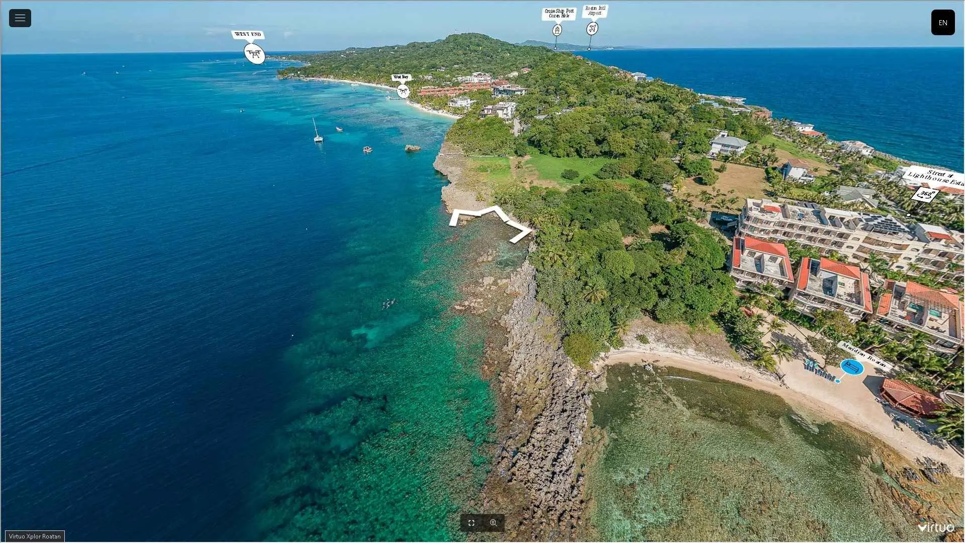
Best Shore Snorkeling Spots in Roatan (2025 Guide)
Why Dive Into Roatan With a Local Divemaster?
As your PADI-certified Divemaster & Roatan expert , I craft immersive experiences you won't find on cruise excursions:
🐠 Exclusive Dive/Snorkel Advantage
- ✅ Max 4 guests per tour - Your private group, my undivided attention
- ✅ "No Dock, No Charge" Guarantee - Full refund if your ship misses port
- ✅ Secret Reef Access - I'll show you coral gardens even locals don't know
🦥 Popular Add-On Adventures
- • Monkey & Sloth Sanctuary (Air-conditioned transport included)
- • Boat Snorkeling Upgrades - Reach untouched walls at Brady's Key
📞 Limited Daily Bookings - [Get Your Custom Itinerary] Explore my Best Roatan Shore Snorkeling Tours
Why would you not snorkel with an Expert? Claim Your Private Roatan Snorkeling Tour Now
⬇️ Explore our FAQ ⬇️
Roatan Snorkeling Maps
West Bay Snorkeling Map – Roatan’s Premier Shore Dives
Explore Roatan’s most accessible and vibrant snorkeling sites with our expert West Bay snorkeling map , featuring GPS-verified locations and depth guides for these top spots:
🔹 Texas (Salt Life Point / Rino Phores / Sandra’s Grotto)
Depth: 20–80 ft | GPS: 16.2656102, -86.6032685. Highlights: East-to-west currents feed massive sea fans, giant barrel sponges, and schools of cubera snapper, horse-eye jacks, and barracuda. Pro Tip: Catch a drift ride along the reef wall (20–30 ft) for effortless snorkeling.
🔹 Black Rock (Tommy’s Pit Stop / Willie’s Wonder)
Depth: 10–130+ ft | GPS: 16.27033, -86.602877. Highlights: Vertical coral cathedrals with wire coral and crevices sheltering lobsters and eels. Sandy channels parallel to shore transition to a dramatic drop-off.
🔹 Mandy’s Eel Garden (Temptation / Joe Wagner)
Depth: 10–120+ ft | GPS: 16.272472, -86.602129. Highlights: Garden moray eels weave through coral bommies. Caution: Watch for boat traffic near the glass-bottom boat route.
🔹 Butcher’s Bank (Chloe’s Coral / Bill Perkin’s Peace)
Depth: 10–140 ft | GPS: 16.2786067, -86.6042216. Highlights: Maze-like coral formations with sandy alleys. Note: Avoid midday boat traffic.
Why Snorkel West Bay?
- ✅ No boat needed – All sites are shore-accessible (perfect for cruise visitors).
- ✅ Diverse marine life – From macro critters to pelagics.
- ✅ GPS coordinates – Navigate precisely to each site.
📌 Downloadable Map with depth markers and secret spots.
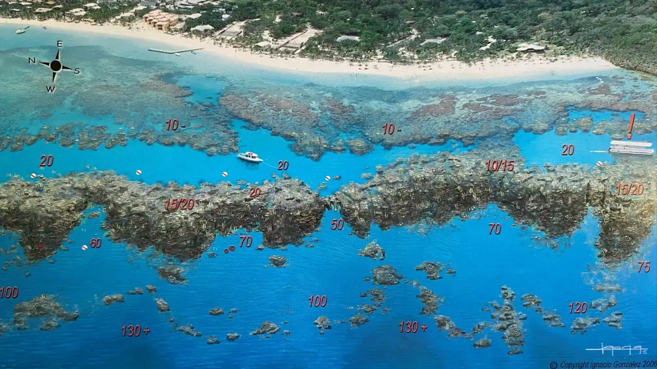
16. West Bay – Mandy’s Eel Garden – Temptation – Joe Wagner
West Bay Beach Snorkeling Map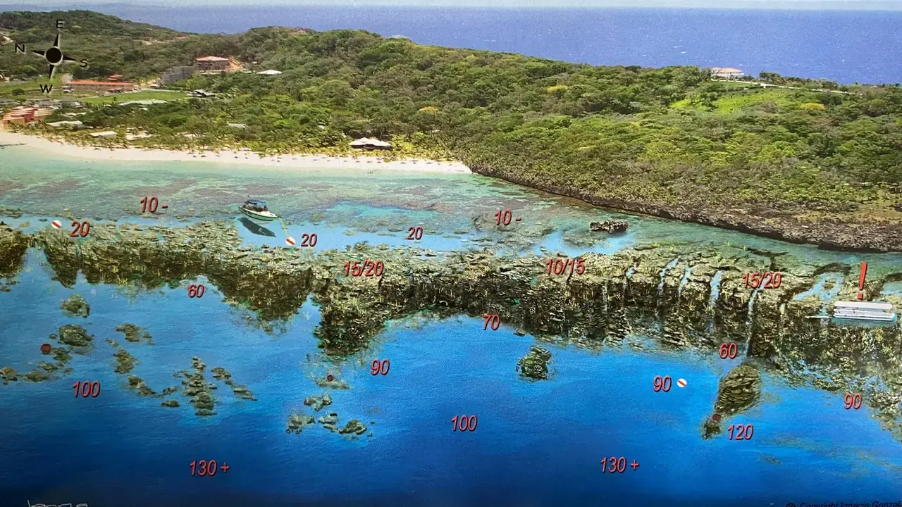
14. West Bay Blackrock Tommys Pit Stop Willies Wonder
West Bay Beach Snorkeling Map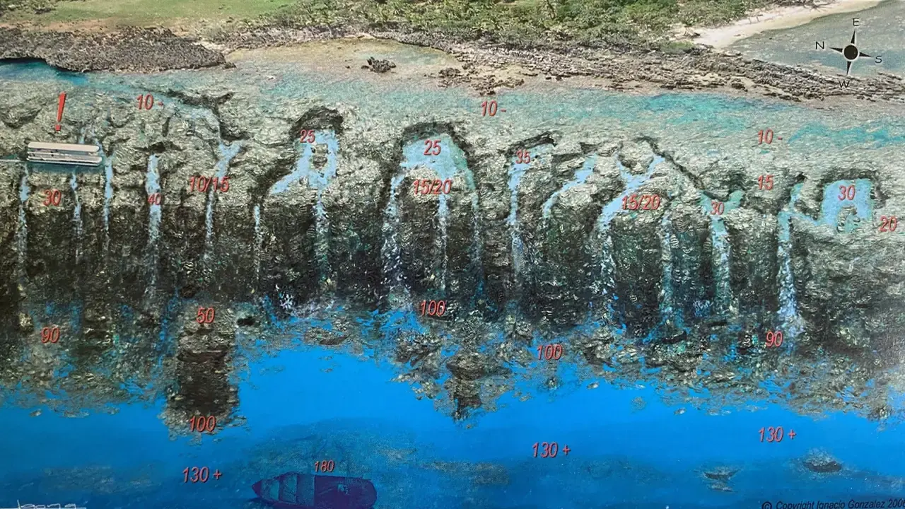
12. West Bay – West End Wall – Buca Quay – Marylin’s Mystery
West Bay Beach Snorkeling Map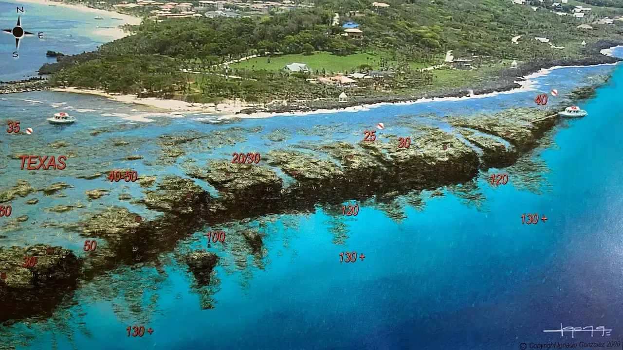
10. West Bay Point Texas – Rino Phores – Sandra’s Grotto
Caution: Current can be strong in this area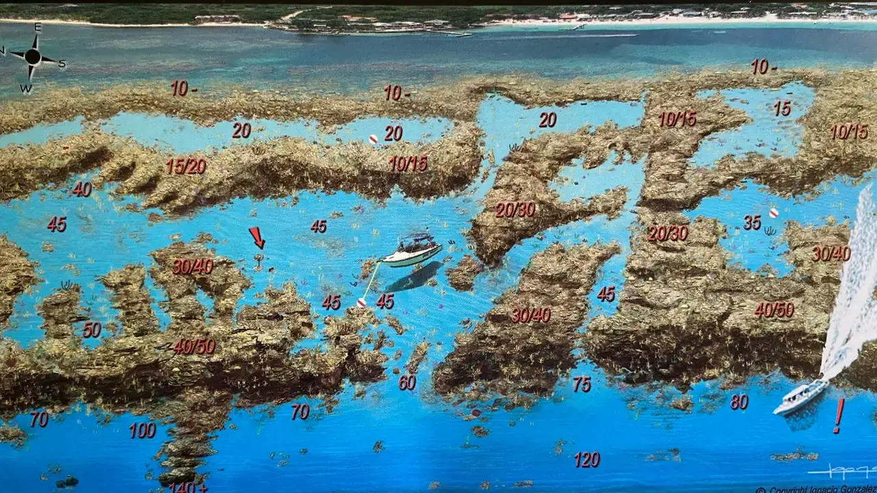
18. West Bay – Butcher’s Bank – Chloes Coral – Bill Perkins Peace
Note: Avoid midday boat traffic. West Bay Beach Snorkeling MapWest End, Half Moon Bay Snorkeling Map
Experience Roatan’s most diverse snorkeling with our detailed West End snorkeling map , featuring GPS-verified sites like Moonlight Reef, Dixie’s Wall, and Half Moon Bay’s dramatic drop-offs.
🔹 Moonlight / Lighthouse Reef
Depth: 10–140+ ft | GPS: 16.3047352, -86.5976975. Highlights: Coral-covered slopes with schooling grunts and occasional reef sharks. Caution: Heavy boat traffic near the channel.
🔹 Dixie’s Wall
Depth: 15–130 ft | GPS: 16.306459, -86.59742. Highlights: Vertical wall plunging into the Cayman Trench, adorned with deep-water sea fans and tube sponges. Sand channels host peacock flounders and garden eels.
🔹 Half Moon Bay Wall / Vern’s Dropoff
Depth: 10–130+ ft | GPS: 16.30919, -86.596117. Highlights: Shallow coral gardens (10–30 ft) for snorkelers, with rare seahorse sightings. Adjacent to RIDE submarine tours.
🔹 Grape Escape / Lara’s Rainbow / Glory to Ukraine
Depth: 10–140+ ft | GPS: 16.310548, -86.595506. Highlights: Wreck debris at 36 ft, pearl shrimp in crevices, and cleaner wrasse stations at 40 ft.
Why Snorkel West End & Half Moon Bay?
- ✅ Less crowded than West Bay – More marine life diversity.
- ✅ Dramatic topography – Walls, swim-throughs, and sandy chutes.
- ✅ Cruise-friendly – 10-minute boat ride from Coxen Hole port.
📌 Local Tip: Snorkel Half Moon Bay at high tide for calm conditions and better visibility.
💡 Free Download: [Get our West End Snorkel Map PDF] with current patterns and secret sites like Lara’s Rainbow.
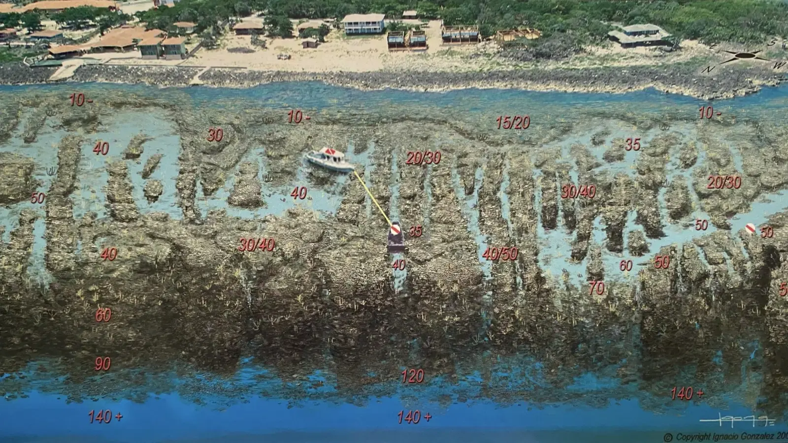
46. West End – Grape Escape – Laras Rainbow – Glory to Ukraine
West End Half Moon Bay Snorkeling Map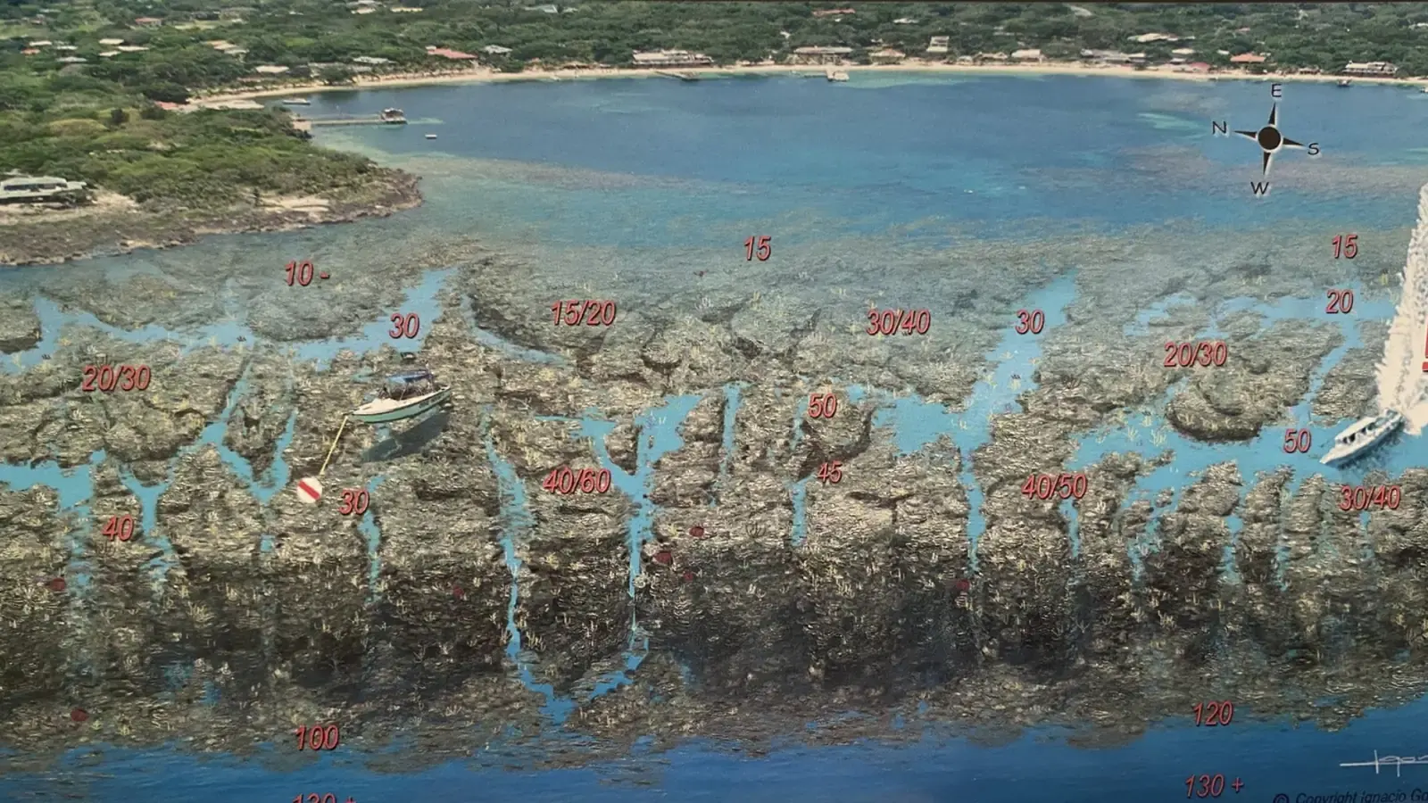
44. West End Half Moon Bay – Half Moon Bay Wall – Verns Drop Off
West End Half Moon Bay Snorkeling Map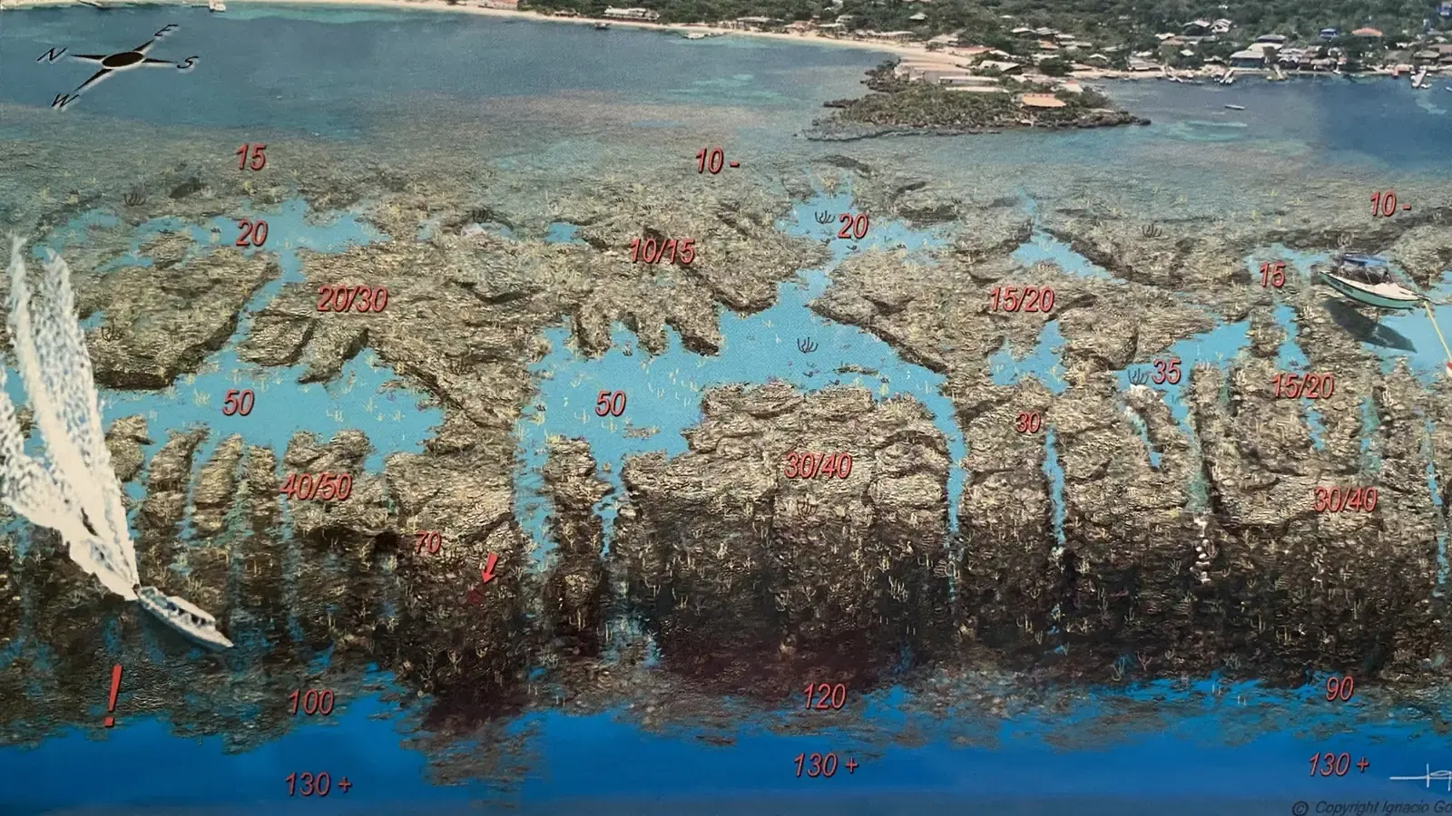
38. West End Half Moon Bay -Dixies
West End Half Moon Bay Snorkeling Map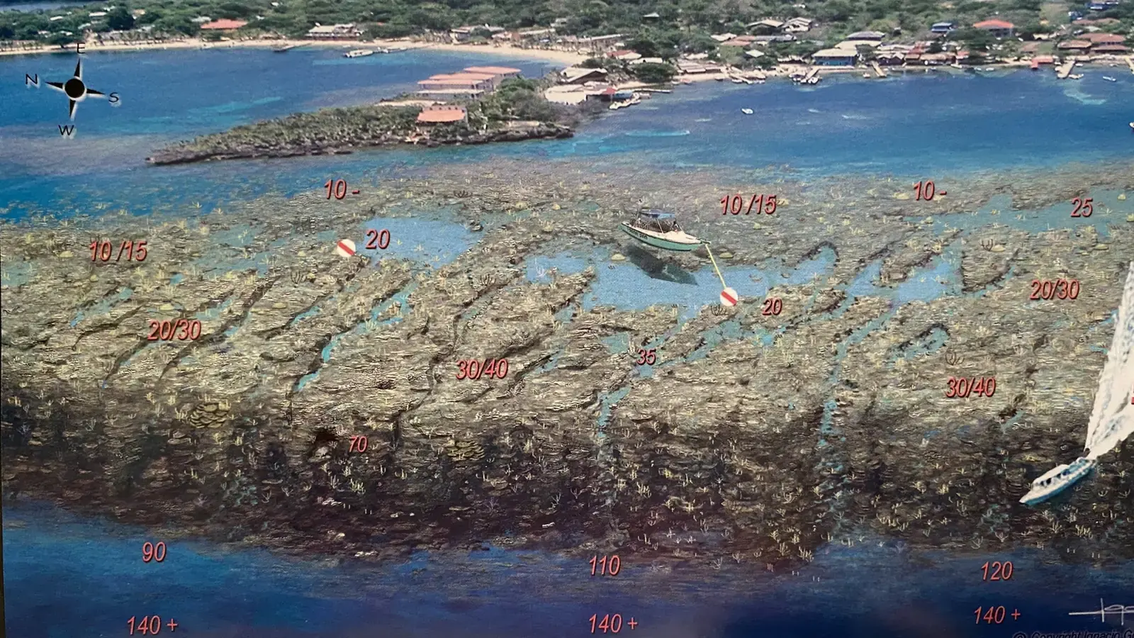
36. West End Half Moon Bay – Moonlight – Light House Reef
West End Half Moon Bay Snorkeling MapBig French Key & Little French Key Snorkeling Map – Roatan’s Private Island Paradises
Escape to Roatan’s most luxurious snorkeling destinations with our detailed map of the French Cayes. These private islands offer virgin coral walls, sunken wrecks, and aquarium-like shallows – all just 5 minutes by boat from mainland Roatan.
🔹 Big French Key Cut & PG&ME Coco View
Depth: 5–60 ft | GPS: 16.3502043, -86.4460447. Highlights: "The Aquarium" (5-15 ft): Neon damselfish clouds in brain coral formations. Coco View Wall: Vertical drop to 60 ft with rare black coral trees. Exclusive Perk: Only accessible via Coco View Resort or private tour.
🔹 Mr. Bud’s Wreck (French Key Cut)
Depth: 20–40 ft | GPS: 16.348363, -86.446089. Highlights: 1950s fishing trawler encrusted with orange cup corals. "The Fish Bowl" – Glassy water where tarpon circle the wreck.
🔹 Forty Foot Point / Ben’s Clubhouse
Depth: 30–130+ ft | GPS: 16.3522124, -86.4354044. Signature Feature: Underwater limestone clubhouse at 40 ft (perfect for dive-through selfies).
🔹 Valley of Kings (Fantasy Island - French Cays)
Depth: 30-130+ ft | GPS: 16.350948 -86.4378207. Highlights: This coral barrier protects Fantasy Island and keeps the Beach Wave & Sargassum Free all year round.
Why These Keys Beat Mainland Snorkeling?
- ✅ Zero Crowds – Private islands mean untouched coral.
- ✅ Wreck + Reef Combos – Unique to the French Cayes.
- ✅ All Skill Levels – From 3ft turtle gardens to 100ft walls.
📌 Local Secret: Visit Big French Key at slack tide (8 AM-5 PM) for crystal visibility.
💡 Premium Download: Get Our French Cayes Snorkel Map with GPS marks for Mr. Bud’s Wreck and hidden coral chimneys.
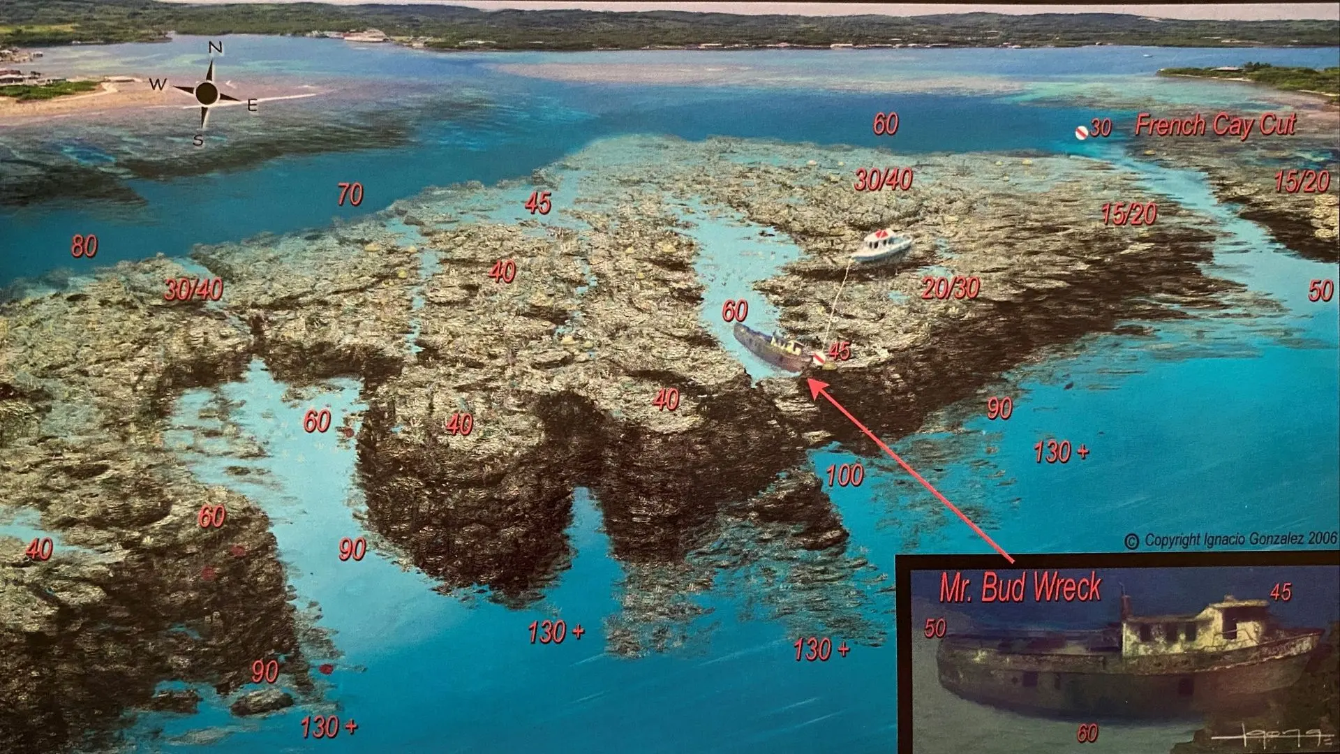
104. Bradys Key – Mr Buds Wreck – French Key Cut
Brady’s Cay Snorkeling Map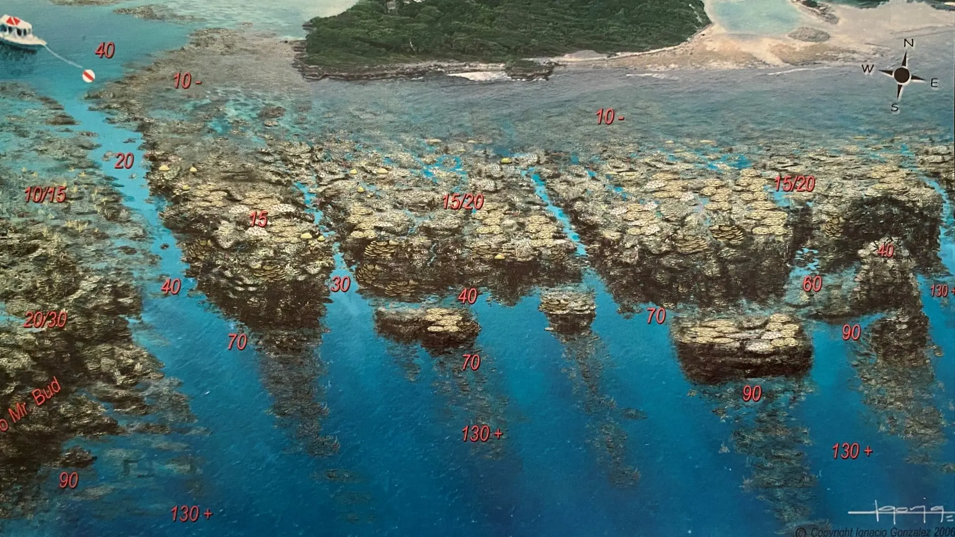
106. Big French Key Cut – PG&ME@CocoView
Big French Key Snorkeling Map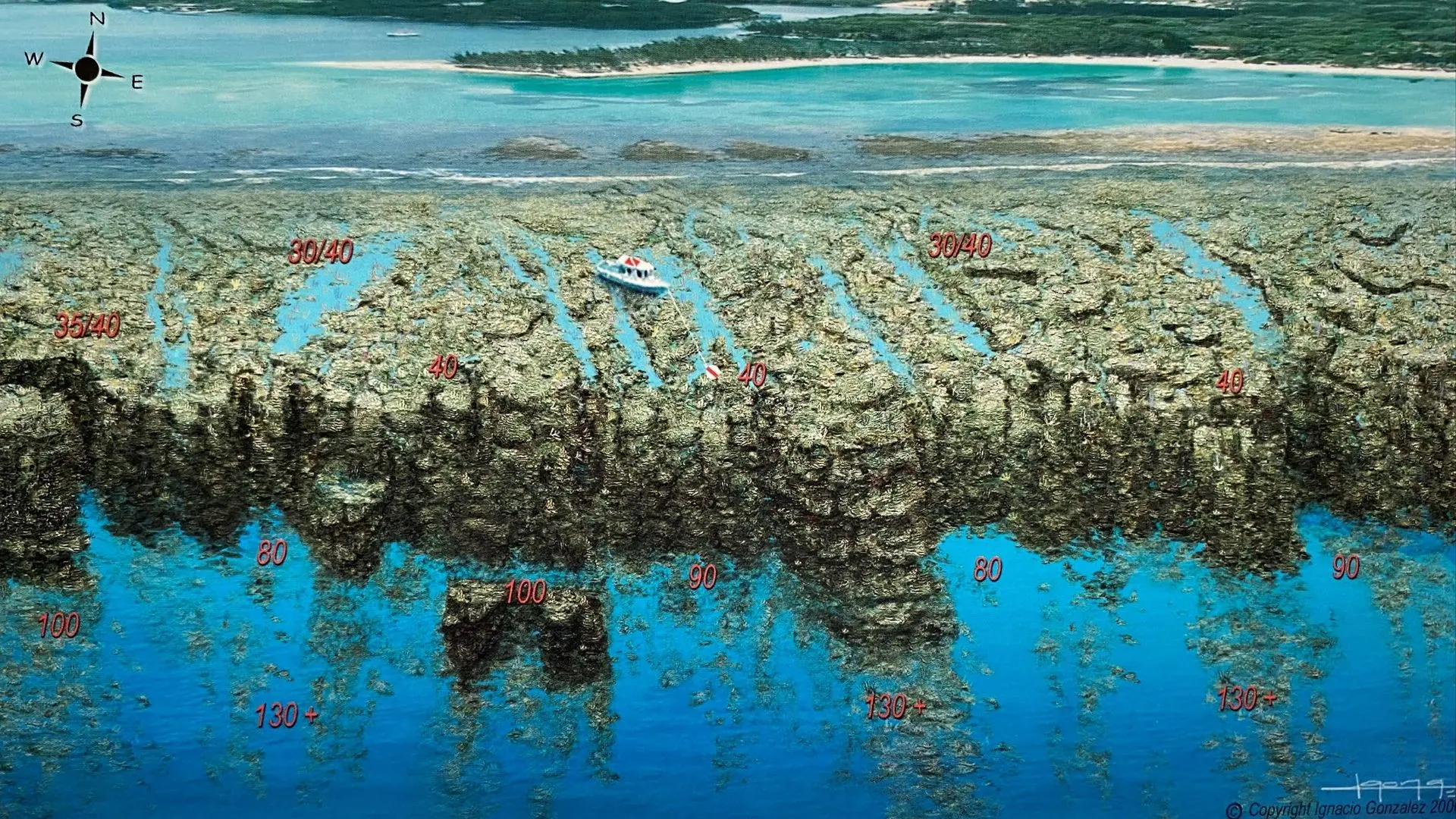
110. Forty Foot Point – Bens Clubhouse
Little French Key Snorkeling Map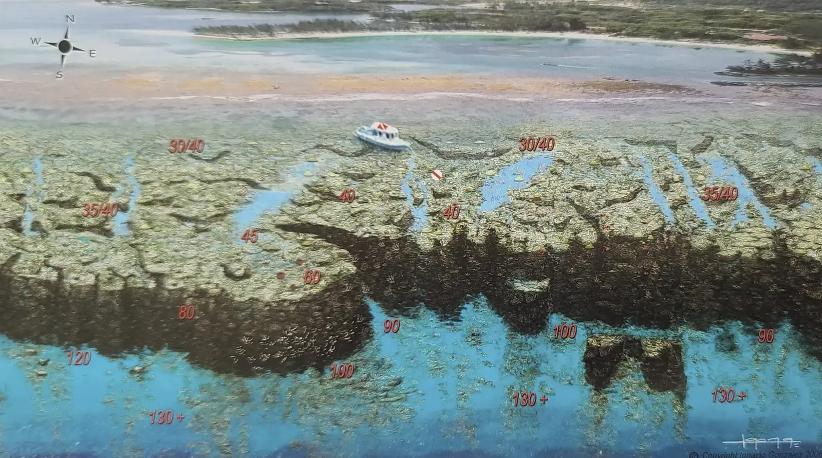
108. Valley of Kings – Fantasy Island – French Cay
Fantasy Island – French Cay Snorkeling MapFantasy Island & Coco View Reef Maps Dual-Access
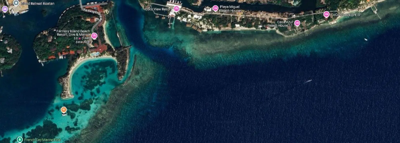
Experience Roatan’s legendary wall dive from two prime locations – Fantasy Island’s resort deck or Coco View’s private pier. This world-class site delivers unmatched marine diversity just steps from shore.
🔹 Access Points & Key Features
📍 From Fantasy Island Resort Deck — Boat-Free Access: 2-minute swim to the wall’s northern edge. Day Pass Option: Check our Day Pass Options. 📍 From Coco View Resort Pier — Direct Entry: Ladder drops you onto the wall’s shallow plateau (15 ft). Resort Perk: Divers-only Resort.
🔹 Forty Foot Point / Ben’s Clubhouse
Depth: 30–130+ ft | GPS: 16.3522124, -86.4354044. Signature Feature: Underwater limestone clubhouse at 40 ft (perfect for dive-through selfies).
🔹 Valley of Kings (Fantasy Island - French Cays)
Depth: 30-130+ ft | GPS: 16.350948 -86.4378207. Highlights: This coral barrier protects Fantasy Island and keeps the Beach Wave & Sargassum Free all year round.
🔹 Newman's Wall / Karen's Octopus Garden / Little French Key’s House Reef
Depth: 3–25 ft GPS : 16.3535711 -86.4350463. Star Attraction: Resident hawksbill turtles in the seagrass beds. Day Pass: Check out our LFK Day Pass Packages.
🔹 Coco View Wall & Prince Albert's Wreck
Depth: 20–130+ ft | GPS: 16.35697, -86.43139. Key Features: "The Prince Albert’s Playground": Shallow coral gardens (15-30 ft) with frequent eagle ray sightings. Vertical Wall Drop-Off: Plummets to 130+ ft, adorned with giant sponges and black coral. Fish Tornadoes: Schools of creole wrasse and horse-eye jack swarm the wall’s edge.
Why Divers & Snorkelers Love This Spot
- ✅ No Boat Needed – Unique among Roatan’s premium sites.
- ✅ Multiples Experiences in One – Inner Protected reefs, Shallow coral gardens + deep wall.
- ✅ Wreck Combo Potential – Pair with the Prince Albert Wreck ([see our Wrecks Page]).
📌 Pro Tip: Fantasy Island access has better morning light for photography.
110. Forty Foot Point – Bens Clubhouse
Little French Key Snorkeling Map108. Valley of Kings – Fantasy Island – French Cay
Fantasy Island – French Cay Snorkeling Map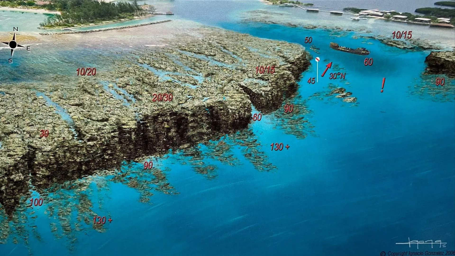
112. Newmans Wall – Karen Octopus Garden – Fantasy Island – Prince Alberts Wreck
Fantasy Island Snorkeling Map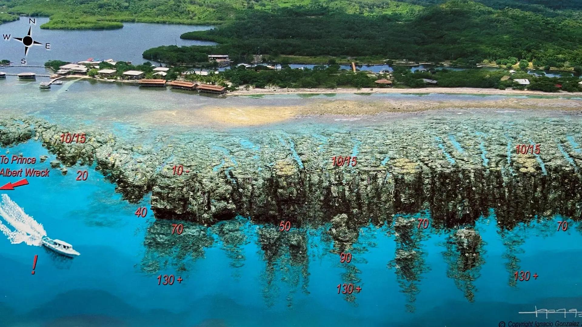
116. Prince Alberts Wreck – Coco View Wall – Coco View
Coco View Snorkeling MapMedia Luna Resort Snorkeling – Exclusive Half Moon Bay Coral Sanctuary
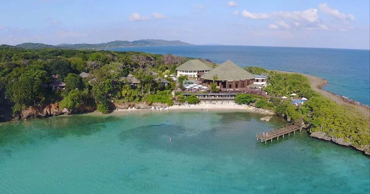
Access Roatan’s most pristine house reef at this adults-only luxury resort. With day-pass snorkeling available , you can explore:
🔹 Half Moon Bay Wall & Caribe Point
Depth: 10–180+ ft | GPS: 16.365242, -86.393417. Highlights: "The Coral Cathedral": Towering sponges at 40 ft. Stingray Alley: Sandy channel at 25 ft (morning sightings). Resort Perk: Guided tours include UV night snorkeling ( unique selling point ).
🔹 Day Pass Inclusions ($120 value): ✅ Gear rental (mask, fins, vest) ✅ 60-minute+ guided snorkel tour ✅ All-included lunch & drinks. 📌 Pro Tip: Book the 8 AM tour for glassy conditions and active reef life.
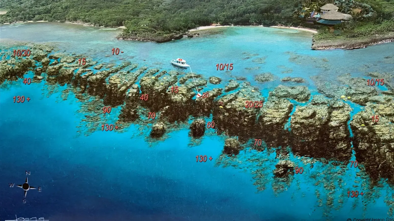
122. Media Luna – Half Moon Bay
Media Luna Hotel Snorkeling Map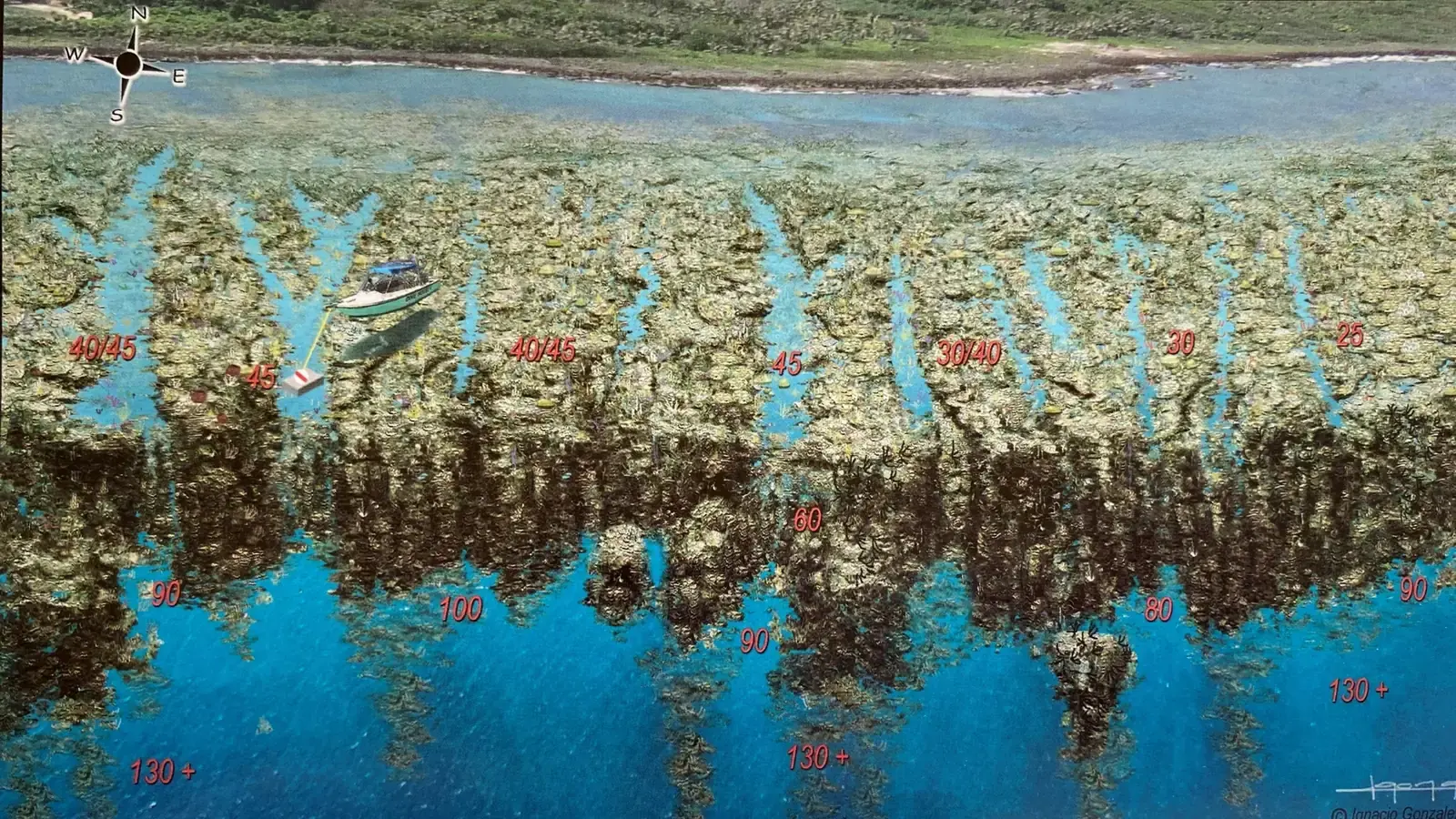
124. Media Luna – Caribe Point
Media Luna Spa And Beach Resort Snorkeling MapMahogany Cay & Mahogany Bay Snorkeling – Cruise Passenger’s Snorkeling Guide
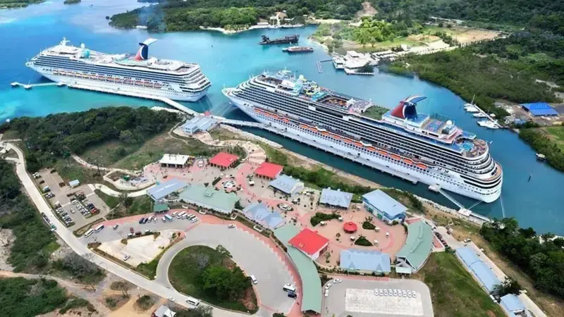
Step off your cruise ship into Roatan’s easiest snorkeling adventure at Mahogany Bay’s private cay. Just a 5-minute boat ride from the Carnival cruise terminal, this sheltered marine sanctuary offers:
🔹 Lita’s Hole / D2T (Mahogany Cay’s Club House Reef)
Depth: 10–130 ft | GPS: 16.3193349, -86.4946389. Highlights: Swim through entrance at 26ft, exit at 65ft. Cruise Perk: Exclusive access for Carnival passengers.
Why Snorkel Mahogany Cay?
- ✅ Zero Transportation Stress – Direct access from the cruise terminal.
- ✅ Guaranteed Calm Conditions – Leeward side of the cay blocks waves.
- ✅ No Gear? No Problem – Rentals available at the beach club
- ❌ Cruise Ship Guests Only
📌 Pro Tip: Book the "VIP Beach Break" excursion for shaded cabanas and reef guides.
💡 Free Download: [Get Our Mahogany Bay Snorkel Map] with secret spots most cruise passengers miss!
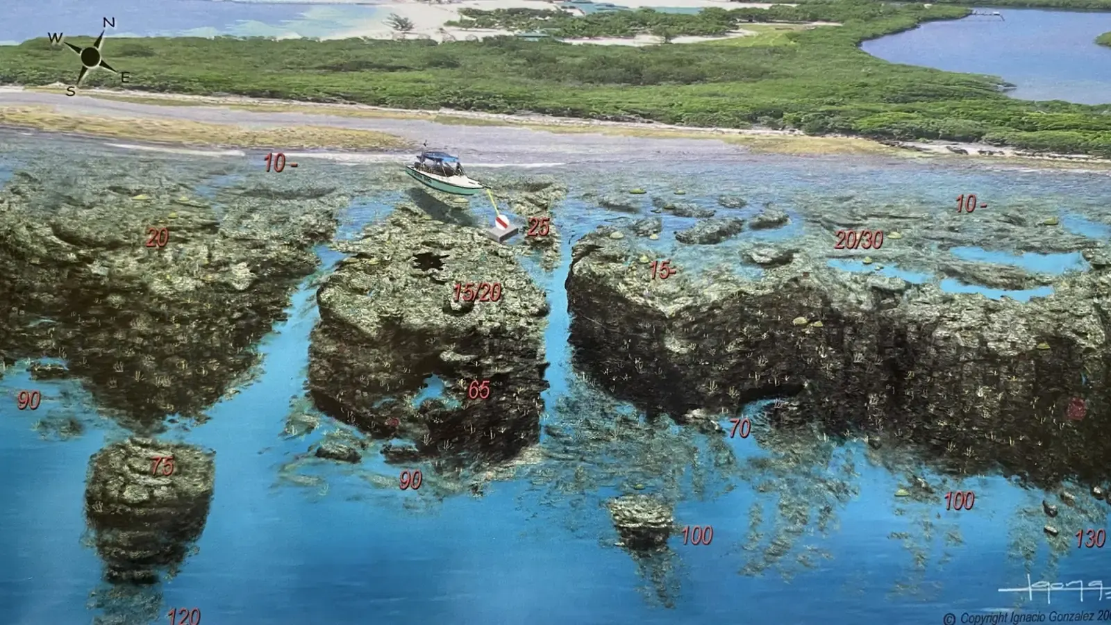
92. Mahogany Cay- Litas House D2D
Mahogany Bay Snorkeling MapBook a Private Island Brewery Tour Include Shopping & Beach Break Now
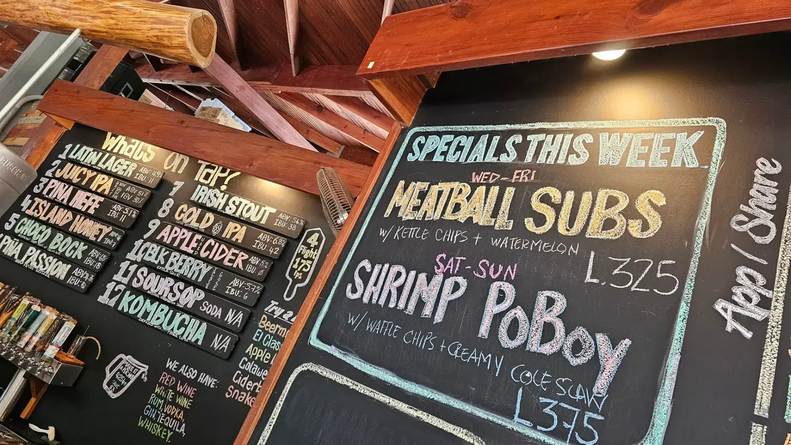
Click here to Taste Authentic Crafted Island Made Brews, and Beach Relaxation with Your Personal Guide. Pick-up Included from Roatan Village Town Center or Mahogany Bay Isla Tropicale Cruise Ports. Choose Your Optional Addons: Monkey & Sloth Sanctuary Tour and/or Boat Snorkeling available. IMPORTANT! The Island Brewery is closed on Monday and Tuesday. We visit Las Verandas at Pristine Bay where they have their beer on tap instead!
Frequently Asked Questions About The Roatan Snorkeling Maps
Where is the best shore snorkeling in West Bay? (Tabyana Beach)
Start by Infinity Bay Resort's Dock and follow the wall toward Grand Roatan Resort, you can go all the way to Texas if the weather is in your favor!
Can I snorkel Tabyana Beach without a resort day pass?
Absolutely, Tabyana Beach is in Fact West Bay Beach It is public; Tabyana is a Corporate Company name. You need a Day Pass to Access Tabyana's Beach Club.
Is Half Moon Bay good for beginner snorkelers?
Absolutely! The protected cove has calm, shallow waters (3-15ft) perfect for first-timers. You can find Turtles, Eagle Rays, Moray Eels just inside the Bay. Pro Tips - Must-Do: It is also a Very Good Night Snorkeling Spot.
How do I snorkel Fantasy Island’s reef without staying there?
Day passes ($60) include lunch, drinks, beach chairs, pool & dock access to the Fantasy Island
Can non-guests snorkel Coco View Wall?
The resort’s pier is for guests only. You can swim to Coco View's Wall from Fantasy Island's Deck.
Can non-guests snorkel at Little French Key?
Little French Key does not have ideal access to the French Key Cut snorkeling site. Their packages are overpriced I recommend that you book another of our Private Islands inside our Top 3 All-Included Islands Day Pass
How do I reach Brady’s Key’s snorkel sites?
I recommend you book our Secret Island Guided Snorkeling tour here: Top 3 All-Included Islands Day Pass
What makes Big French Key different from Little French Key?
Big French Key offers cheaper access and a bigger resort and is also more ethical, with no zoo on this island book your Guided Snorkeling tour here: Top 3 All-Included Islands Day Pass
Ready to Book Your Unforgettable Roatan Snorkeling Adventure?
📞 Contact & Reservation : Start your adventure today 👇
📥 Add me as a Friend on facebook to facilitate our exchanges
📩 Send me a message Patrice Roatan Quebecois
💬 Start planning your stay immediately with an Expatriate Tour Guide, Divemaster & Quebec Expert!
🏛️ Join our community on Facebook 👉 Roatan Honduras Excursions | Safe Travel & Cruise Group